
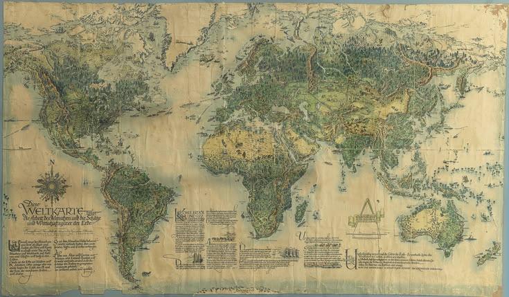

Antique world maps are much more than old representations of continents and oceans. They are artistic records of how people in different periods understood the world around them. The Art and History Behind Antique World Maps can be explored through their intricate illustrations, handwritten details, geographical interpretations, decorative borders, and the stories connected to exploration and discovery. Every map can reveal something about the technology, culture, ambitions, and knowledge of the society in which it was created.
Today, antique world maps are appreciated by collectors, historians, researchers, interior designers, and anyone fascinated by the development of geographical knowledge. Their combination of historical importance and visual beauty makes them remarkable objects that continue to attract attention centuries after they were first produced.
The Origins of Early World Maps
The history of world mapping reaches back thousands of years. Long before modern surveying techniques and digital navigation existed, civilizations created maps to represent landscapes, trade routes, kingdoms, waterways, and important settlements. Early mapmakers depended on travelers, sailors, astronomers, merchants, military information, and observations of the natural environment.
Ancient societies often viewed geography through the knowledge available to them at the time. Their maps could include accurate information about familiar regions while presenting distant areas with considerable uncertainty. This mixture of observation and imagination gives historical maps much of their character.
Ancient Greek scholars made significant contributions to geographical thinking. Figures such as Ptolemy developed methods for representing locations using coordinates. His geographical writings influenced mapmaking for many centuries and helped establish the idea that the Earth's surface could be systematically represented.
Medieval Maps and Religious Perspectives
During the medieval period, European maps often reflected religious and cultural ideas alongside geographical information. Some world maps were created to communicate a particular understanding of the world rather than to provide precise navigational guidance.
The famous medieval mappae mundi frequently placed important religious locations at prominent positions. These maps could contain drawings of biblical events, legendary creatures, distant peoples, and symbolic representations of important places.
Rather than judging these maps solely by modern standards of accuracy, historians study them as evidence of medieval thought. They demonstrate how geography, religion, storytelling, and cultural traditions could come together in a single visual document.
The Influence of Exploration
The Age of Exploration dramatically changed the development of world maps. As European sailors traveled across the Atlantic, around Africa, and toward Asia, they brought back new geographical information. Previously unknown coastlines gradually began appearing on maps.
Exploration created both opportunities and challenges for cartographers. Information from different voyages could conflict with earlier reports, while some newly discovered regions remained poorly understood. Mapmakers had to compare sources and decide how to represent incomplete knowledge.
As geographical information expanded, maps became increasingly valuable. Governments, merchants, sailors, explorers, and military planners all depended on geographical knowledge. The demand for maps encouraged the development of specialized cartographic workshops and printing businesses.
The Artistic Beauty of Antique Maps
One of the most appealing characteristics of antique maps is their artwork. Historical mapmakers often treated maps as decorative works as well as practical documents.
Elaborate borders, illustrated sea creatures, ships, compass roses, decorative lettering, mountains, forests, and city views could transform a geographical document into an artistic composition. Large maps sometimes featured elaborate cartouches containing the map's title, dedication, publication information, or portraits.
Color was also an important part of traditional mapmaking. Depending on the period and purpose of the map, colors could identify political boundaries, geographical features, waterways, or decorative elements. Hand-colored maps are particularly interesting because individual maps could contain subtle variations created by the person applying the color.
Map Cartouches and Decorative Details
The cartouche is one of the most recognizable decorative features found on many antique maps. Usually positioned in an open area of the map, a cartouche could contain the title, scale, dedication, publisher's name, or additional notes.
Cartographers sometimes surrounded cartouches with elaborate artistic designs. Figures, animals, plants, shields, ships, crowns, and architectural elements could all appear within these compositions.
For modern viewers, these details provide another reason to study antique maps closely. A map that initially appears to be a geographical document can reveal a surprising amount of visual information when examined carefully.
The Role of Engraving and Printing
The development of printing technologies transformed map production. Engraving allowed cartographers and publishers to reproduce detailed geographical information more efficiently than many earlier methods.
Copperplate engraving became particularly important in European mapmaking. Fine lines could be engraved onto a copper plate and transferred onto paper through a printing process. This technique allowed mapmakers to create delicate coastlines, lettering, shading, and decorative illustrations.
Printed maps could then be distributed to a wider audience. Although many maps remained expensive objects, printing helped increase the availability of geographical information and supported the growing interest in exploration and world geography.
How Antique Maps Show Changing Geography
One of the most fascinating aspects of antique maps is that geographical knowledge was not fixed. Borders changed, place names evolved, coastlines were corrected, and entire regions were represented differently as new information became available.
Comparing maps from different periods can therefore provide a visual history of geographical understanding. A coastline that appears uncertain on an earlier map may become more recognizable on a later one. Countries and territories may appear under different names or boundaries.
These changes make antique maps valuable historical sources. They show not only what people knew, but also what they believed they knew at particular moments in history.
Maps as Records of Political Power
Maps have often been connected with politics and power. Representing a territory on a map could communicate ideas about ownership, authority, influence, and national identity.
Political boundaries on historical maps can therefore provide important clues about past conflicts and territorial changes. Some maps emphasized particular kingdoms or empires, while others were designed for administrative or military purposes.
Mapmakers were not always completely neutral observers. The information they included, emphasized, or omitted could reflect the interests of publishers, governments, patrons, or societies. For historians, this makes maps valuable evidence that must be studied within their broader historical context.
Maritime Maps and the World of Navigation
The oceans occupy a central place in the history of cartography. Sailors needed reliable information about coastlines, ports, currents, islands, and navigational routes.
Nautical charts developed specialized features intended to assist maritime travel. Compass roses, rhumb lines, coastal details, and harbor information could make these charts particularly useful to navigators.
Decorative sea monsters and sailing ships sometimes appeared in areas where geographical knowledge was limited. These illustrations are now among the most charming features found on some historical maps.
The Importance of Place Names
Place names are another fascinating element of antique world maps. Names can change because of language, political developments, colonial influence, local traditions, or improved geographical knowledge.
A historical map may therefore contain names that differ considerably from those used today. Researchers can use these names to investigate historical geography and understand how different societies referred to particular regions.
For collectors, unusual place names can also make a map especially interesting. A map may preserve terminology that disappeared from common usage centuries ago.
Antique Maps as Windows Into Exploration
Many antique maps preserve the geographical legacy of exploration. They document the gradual expansion of knowledge about distant lands and oceans.
Maps produced after major voyages could incorporate newly reported coastlines, islands, rivers, and settlements. However, information was not always immediately accurate. Reports could be incomplete or misunderstood, resulting in geographical errors that were later corrected.
These mistakes are part of the historical story. They demonstrate that knowledge develops through observation, comparison, experimentation, and correction.
The Materials Used by Historical Mapmakers
Traditional maps were created using materials that required considerable skill. Paper quality, ink, pigments, engraving plates, printing presses, and binding techniques all influenced the final product.
The surviving condition of a map can tell researchers something about its history. Paper may show signs of aging, folds, repairs, discoloration, or changes caused by storage and exposure.
Because antique maps are often fragile, preservation requires careful handling. Collectors and institutions generally consider environmental conditions, appropriate storage materials, and protection from excessive light when caring for historical paper.
Why People Collect Antique World Maps
Collectors are attracted to antique world maps for many different reasons. Some appreciate their historical significance, while others are interested in their artistic qualities. For some collectors, the appeal lies in a particular geographical region, historical period, cartographer, publisher, or printing technique.
An antique map can also represent a connection to a specific moment in history. Holding a map produced centuries ago provides a tangible link to the people who created, purchased, studied, or used it.
Collectors often enjoy researching the story behind a map. Identifying its date, publisher, cartographer, edition, printing method, and geographical context can make ownership more meaningful.
Antique Maps in Interior Design
The visual appeal of antique maps has also made them popular in interior design. Large historical maps can become striking focal points in libraries, offices, studies, museums, and traditional living spaces.
Their aged appearance and detailed artwork can introduce a sense of history into a room. Reproductions are also widely used when people want the appearance of an old map without handling an original historical document.
Whether displayed as a central feature or as part of a larger collection, maps can combine educational value with decorative appeal.
Studying Antique Maps Today
Modern researchers use advanced methods to study historical maps. High-resolution digital imaging allows delicate details to be examined without repeatedly handling fragile originals.
Digital archives have also made many historical maps accessible to researchers and the public. Scholars can compare maps from different collections, study changing borders, trace historical place names, and examine the development of cartographic techniques.
Despite modern technology, the original physical map remains important. Paper texture, printing characteristics, handwritten annotations, and evidence of previous use can sometimes provide information that a digital image cannot fully reproduce.
Preserving Cartographic Heritage
Preserving antique maps is important because these objects contain historical information that cannot easily be recreated. Each surviving map can contribute to our understanding of geographical knowledge, artistic traditions, exploration, commerce, politics, and cultural development.
Museums, libraries, archives, dealers, and private collectors all contribute to the preservation of cartographic heritage. Proper storage, careful handling, conservation work, and responsible research can help ensure that these materials remain available for future generations.
The Lasting Legacy of Antique World Maps
The Art and History Behind Antique World Maps extends far beyond their geographical content. They are artistic creations, historical records, technological achievements, and reflections of changing human knowledge.
Every coastline, handwritten label, decorative cartouche, compass rose, and illustrated detail can tell part of a larger story. Antique maps show how people imagined distant lands, recorded discoveries, understood political boundaries, and communicated information before modern mapping technologies transformed geography.
Their continued popularity demonstrates that maps are not simply tools for finding places. They can also preserve memories, ideas, ambitions, and artistic traditions. For collectors and researchers alike, antique world maps provide an extraordinary opportunity to explore the relationship between art, history, exploration, and human curiosity.